SoCal Forecast
Updated most Sundays, Tuesdays, and Thursdays
Sunday 8/2/26 6:35 AM
By Nathan Cool
Surf Charts for SoCal
Rincon | Ventura, C-St. | County Line | Malibu | Hermosa | Huntington BeachTrestles | Old Mans | Oceanside | Beacons | Sunset Cliffs
Subscribe to be notified:
Get notified when this report is updated.
At a glance:
Today (Sunday the 2nd) we have a light to moderate mix of fading swell from Genevieve and localized NW wind swell. Smaller surf is on tap through the workweek. Moderate SW ground swell is due this coming weekend. Moderate southern hemi swell is becoming likely for the end of next week. Models hint at tropical swell around the end of next week as well. Condition-wise: fair weather and winds at the coast; tide levels are evening out; and water temps remain warm.
BTW, just a quick heads-up before getting to the forecast: July donations came in short (more on that here). So if you haven't donated in a while, now would be a great time to contribute. Thank you everyone!
|
|
|
Current Conditions:
Early this morning, periods were primarily running 13 seconds from 190-200° and 8 seconds from 300-315°.
Most south facing breaks were running waist to chest high with occasional pluses at standouts. Direct west facing breaks were mostly waist high, bigger at SW exposed spots.
Buoys in the outer waters were running 6-7'. Nearshore buoys were about 2-3'.
Tide levels are leveling off from the recent swing. Today we have a 0.5' low around 6:30 AM, a 4.5' high around 12:30 PM, a 2' low around 6:30 PM, and a 4.5' high around midnight.
Water temps were running 73-76° around most of SD. OC was a bit more varied with Huntington Beach reporting 69° yesterday while Newport Beach was 73° and San Clemente Pier 74°. LA was mostly 72-75°. In VC, Channel Islands Harbor reported 74° last night. In SB, Stearns Wharf reported 71° this morning.
New Release: Wave By Wave
Take a journey into the hidden forces behind every swell and the ocean's connection to our human experience. After more than 30 years of tracking storms across the Pacific, Nathan Cool's latest book, Wave By Wave, takes you beyond basic swell prediction and into the deeper story behind the surf. From distant, powerful storms to the moment a wave breaks, you'll learn how to read the ocean with confidence and discover how these rhythmic forces bind us to the sea with a deeper sense of meaning.
Get the Book
Surf Forecast:
Today (Sunday the 2nd) swell from Genevieve continues to fade and will diminish further Monday the 3rd. Light NW wind swell is in the mix from wind activity off NorCal, which should stick around Monday but then drop Tuesday the 4th. The result is small surf for the workweek in the waist high range for most breaks but things should turn around at least somewhat for the weekend.
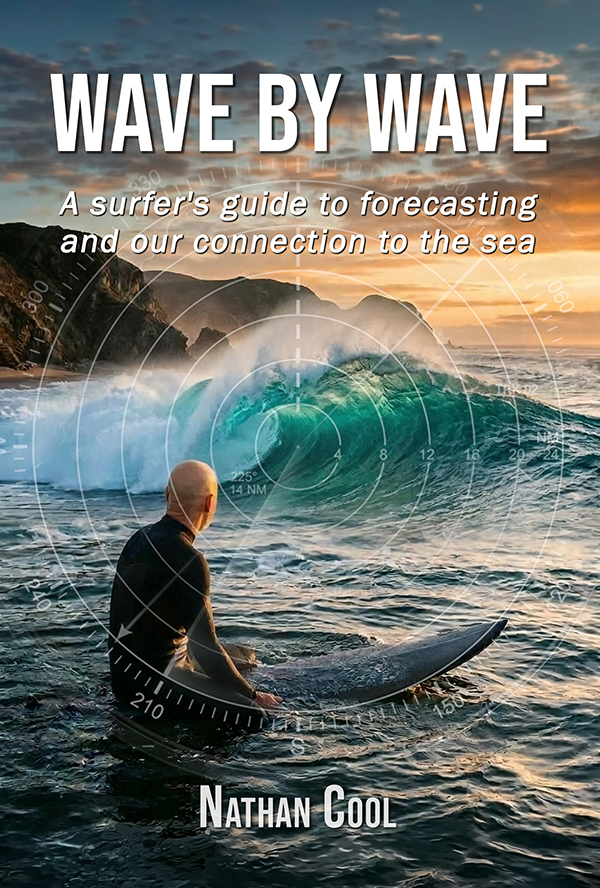
Saturday the 8th (building quickly) into Sunday the 9th (peak) should see SW ground swell from this system that traveled north off Antarctica a few days ago (model generated by XyGrib from NFCENS data):
That system peaked with 30' seas, which works out to chest high sets at south facing breaks, angled from 195° and periods 17 seconds. This swell should continue Monday the 10th with maybe a slight decrease in size, about chest max at south facing spots.
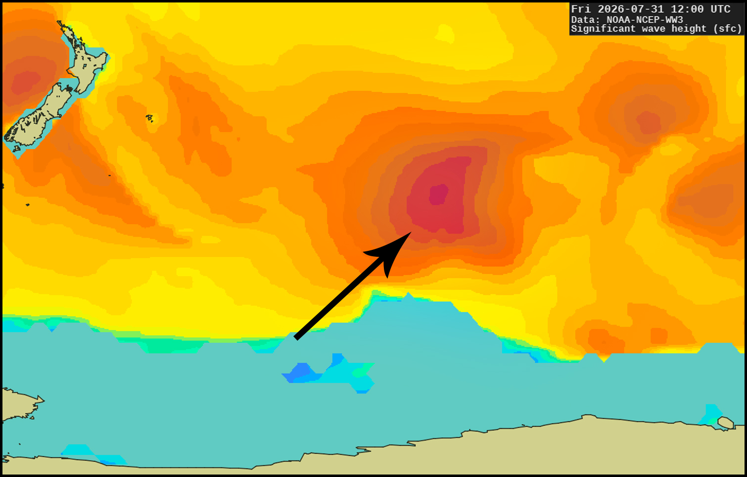
Tuesday the 11th (building day) into Wednesday the 12th (peak) should see spotty, intermittent SW ground swell from this system with decent sized seas but a less than ideal course for SoCal surf (model generated by XyGrib from NFCENS data):
Although housing 35-40' seas, its course will have a high degree of angular decay (page 52). This is just 24 hours out, models are in agreement, so it's safe to call it today for waist to chest high sets at south facing breaks by Wednesday the 12th, angled from 205° and periods 18 seconds. But there'll likely be few waves per set and long lulls between sets. This swell should continue Thursday the 13th.
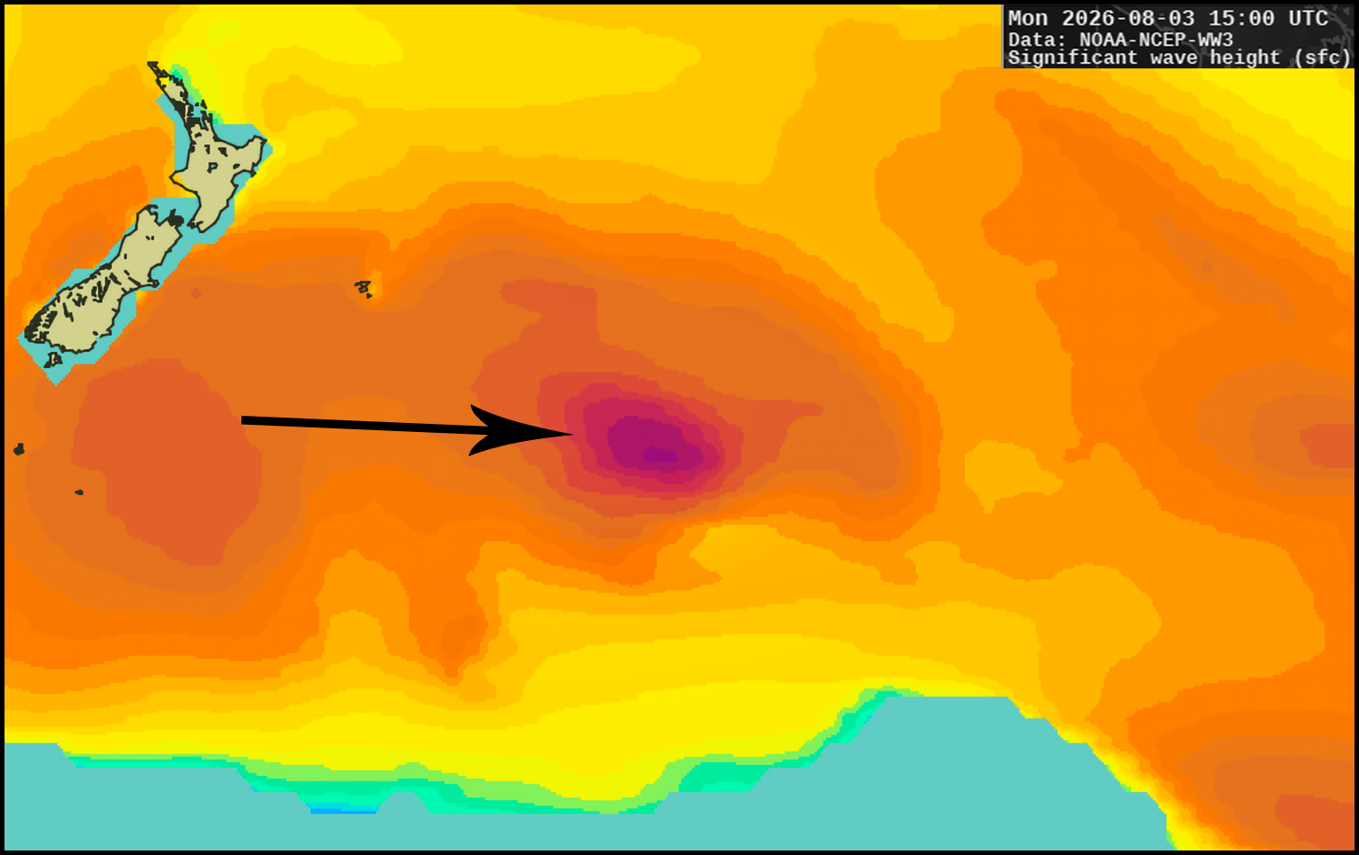
Friday the 14th (building day) into Saturday the 15th (peak) could see SW ground swell from this system taking a better course near New Zealand (model generated by XyGrib from NFCENS data):
With 30'+ seas on that course, SoCal's south facing breaks would be looking at chest+ sets by Saturday the 15th, angled from 215° and periods 17 seconds. This is out on the 4-day models but all models are aligned so confidence is high. After continuing with similar size Sunday the 16th, trailing activity behind that storm could keep at least waist to chest high waves going at south facing breaks Monday the 17th through Wednesday the 19th. I'll need to see how this plays out over the next few days.
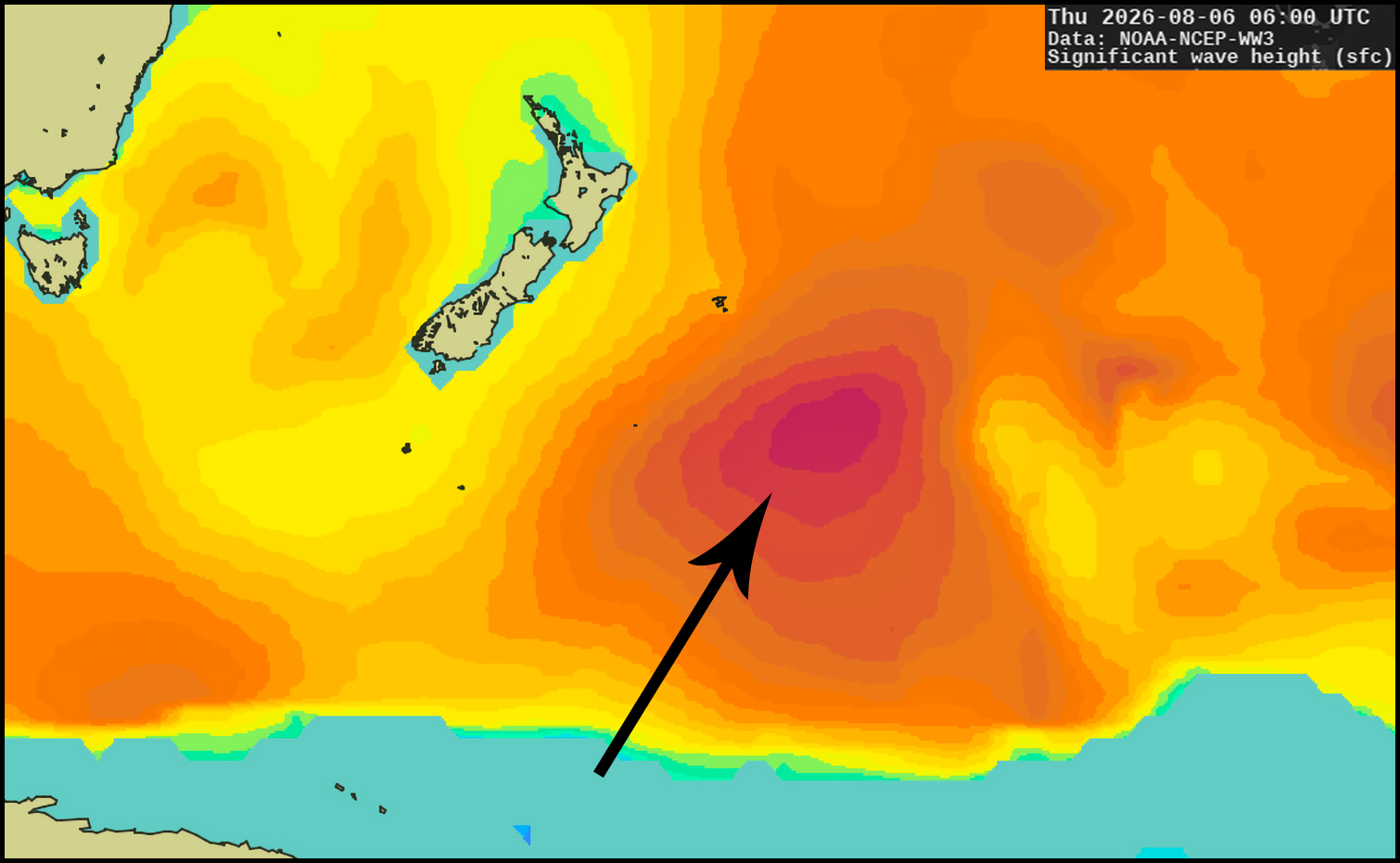
Friday the 14th or Saturday the 15th appears to be the next possible timeframe for more tropical swell in SoCal. But this time around things may not be as favorable as this pattern could take shape, at least temporarily (model by NOAA MAG):
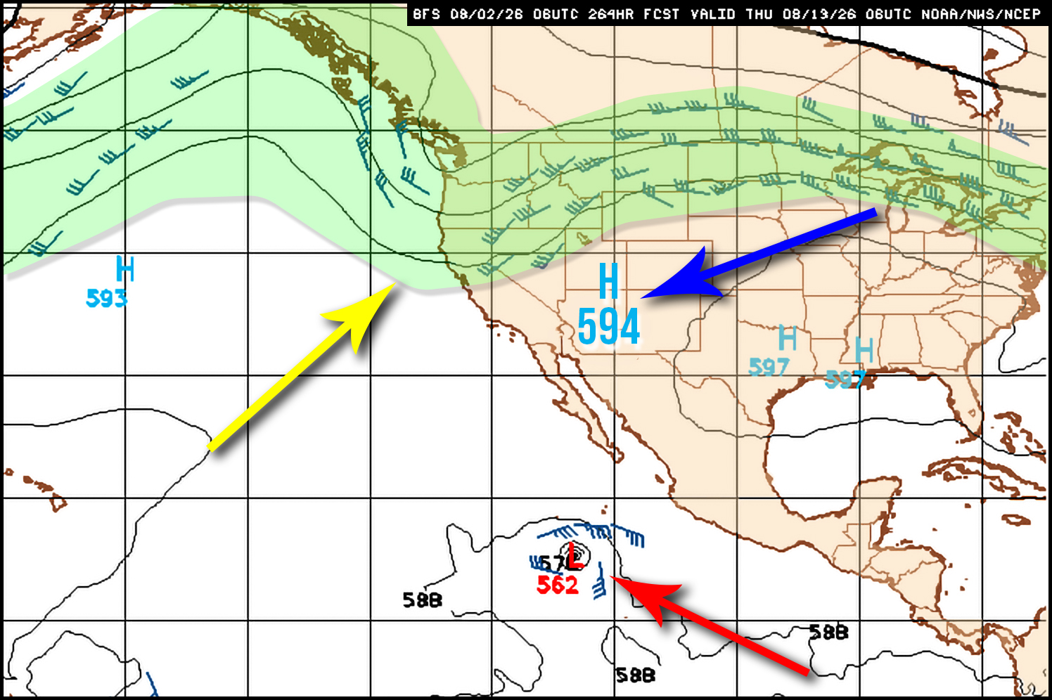
That model shows what we might expect during the second half of next week with a tropical storm (red arrow) moving west-northwest in our swell window. And while high pressure will be centered over the 4-Corners (blue arrow) it looks rather condensed and weak for this time of year. That weakish high will allow a trough of low pressure (yellow arrow) to dip south in the jetstream (green). This kind of pattern tends to thwart hurricanes heading north as low pressure troughs put up a barrier of cooler air ahead of hurricanes. It's also more ideal to have a broader area of high pressure that, spinning clockwise, can guide tropical storms north to position swell more ideally for SoCal. But wait! There's more...
That model above is just the GFS's take on it. Ensemble models (GEFS and NAEFS) are more bullish with tropical swell reaching SoCal as early as Wednesday the 12th. Such is the case with this NAEFS model showing probability for vorticity (spin) being rather strong for a tropical system (red arrow) early next week (model by NOAA MAG):
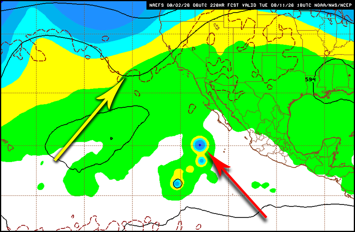
But more importantly, notice in this case that the cool trough (yellow arrow) would be farther west, allowing for a large dome of high pressure to expand over the U.S., which would favor hurricane guidance while not hindering hurricane growth. That model shows what we might expect Tuesday the 11th, which puts tropical swell into SoCal around the 12th or 13th.
With water temps above normal from El Niño and the marine heat wave that's been sitting off the coasts of Baja and SoCal, the likelihood of hurricane swell in the near term is on the high side. Yet it takes more than just warm water. The weather pattern in the coming weeks will determine what to expect, which needs much more monitoring. But as long as I have your support then I can continue to keep an eye on the Pacific to keep you posted. Please remember this report is funded by reader donations and your help is vital to keep it alive (see why here).
|
|
|
Here's a brief look at how the next few days are breaking down so far:
Monday the 3rd looks about waist to chest high at most spots.
Tuesday the 4th looks about waist high at most spots.
Wednesday the 5th looks about waist max at most spots.
Thursday the 6th looks about waist max at most spots.
Friday the 7th looks about waist max at most spots.
Saturday the 8th is expected to run chest high at south facing breaks by midmorning, although swell will be filling in on Saturday, which could make sets spotty.
Sunday the 9th is expected to run chest high at south facing spots.
Monday the 10th, so far, is expected to run chest max at south facing spots.
Tuesday the 11th, so far, is expected to run waist to chest high at south facing spots.
Wednesday the 12th, so far, is expected to run waist to chest high at south facing spots.
Thursday the 13th, so far, is expected to run waist high at south facing spots.
Friday the 14th, so far, looks about chest high on the better sets at south facing breaks as southern hemi ground swell starts to fill in.
Saturday the 15th, so far, is expected to run chest+ at south facing breaks.
Weather Outlook:
Today (Sunday the 2nd) high pressure is weakening over the region and will continue to lose strength through Wednesday the 5th. This should provide slight cooling each day. High pressure is then expected to strengthen Thursday the 6th into Friday the 7th but stay fairly contracted, weakening Saturday the 8th and Sunday the 9th. This should warm things up a tick or two by Friday the 7th, and then cool slightly over the weekend. But by Monday the 10th, high pressure could weaken greatly, leading to more noticeable cooling.
While daytime temps will be noticeably cooler inland than at the coast, beaches will see an odd pattern when it comes to marine layer and early AM temps as water temps will be warmer than overnight land temps. With water temps hovering the low to mid 70s around much of SoCal, this will be about ten degrees warmer than on the sand for the dawn patrols, which should run in the low 60s. This will also influence the thermal inversion each day (see page 131 in Wave By Wave). Marine layer should remain thin as a result with timely burn-offs at the beaches.
Taking all of this into account, here's how I'm calling SoCal beach weather for the next few days:
Today (Sunday the 2nd) should see burn-off around midmorning and max beach temps in the mid 70s.
Monday the 3rd should see AM marine layer with burn-off midmorning and max beach temps in the mid 70s.
Tuesday the 4th should AM marine layer with burn-off mid to late morning and max beach temps in the low to mid 70s.
Wednesday the 5th should AM marine layer with burn-off mid to late morning and max beach temps in the low 70s.
Thursday the 6th should AM marine layer with burn-off mid to late morning and max beach temps in the low to mid 70s.
Friday the 7th should AM marine layer with burn-off midmorning and max beach temps in the mid 70s.
Wind Outlook:
Winds
at 6:00 AM were light and variable most everywhere. Afternoon onshores should run 8-12 mph. No major change is expected over the next few days.
Until my next report (Tuesday), take care, be safe, and smile in the lineup!