SoCal Forecast
Updated most Sundays, Tuesdays, and Thursdays
Tuesday Apr. 16, 2024 6:30 AM
By Nathan Cool
Surf Charts for SoCal
Rincon | Ventura, C-St. | County Line | Malibu | Hermosa | Huntington BeachTrestles | Old Mans | Oceanside | Beacons | Sunset Cliffs
Subscribe to be notified:
Get notified when this report is updated.
At a glance:
Today (Tuesday the 16th) SW ground swell is slowly filling into SoCal, which will peak Wednesday the 17th. A steady yet lighter flow of southern hemi swell lingers for many days after, well into early next week. The next notable swell is NW wind swell potential for the weekend of the 27th-28th. Condition-wise: dry but onshore days ahead; winds moderate for the most part; tide levels are moderate; and water temps are on the cool side in some spots.
|
|
|
Current Conditions:
Early this morning, periods were primarily running 10 seconds from 310°, but SW ground swell with 18-second periods was starting to ping the buoys from 195-205°.
Most breaks were running waist to at times chest high. South facing spots can expect an increase later today.
Buoys in the outer waters were running 9'. Nearshore buoys were averaging 2.5'.
Tide levels are moderate for the next few days. Today we have a 4' high around 4:30 AM, a 0.1' low around noon, and a 3.8' high around 7:30 PM.
Water temps were running 58-60° in most of SD and OC yesterday, although San Clemente Pier reported 62°. LA was mostly 56-58°. In VC, Channel Islands Harbor reported 57° overnight. SB Harbor reported 55° this morning.
Water Contact Advisory: The recent rain has increased the risk of elevated bacteria in the surf-zone. As a reminder, there is a risk of high bacteria levels for at least 72 hours following any measurable rain-event (usually 0.1" or more) during which time water contact should be avoided.
A quick note on the surf charts: NOAA's National Environmental Prediction Center is having a major outage right now, which is affecting the data used to generate the automated surf charts. Hopefully that will be resolved soon. It won't impact this report since I use a variety of models to calculate the surf and weather. This should only affect the automated surf charts until their outage is resolved.
Surf Forecast:
Today (Tuesday the 16th) southern hemisphere ground swell is slowly filling in, which will peak Wednesday the 17th from this relatively high latitude system that traveled northward about ten days ago on an ideal course for SoCal surf (model generated by XyGrib from NFCENS data):
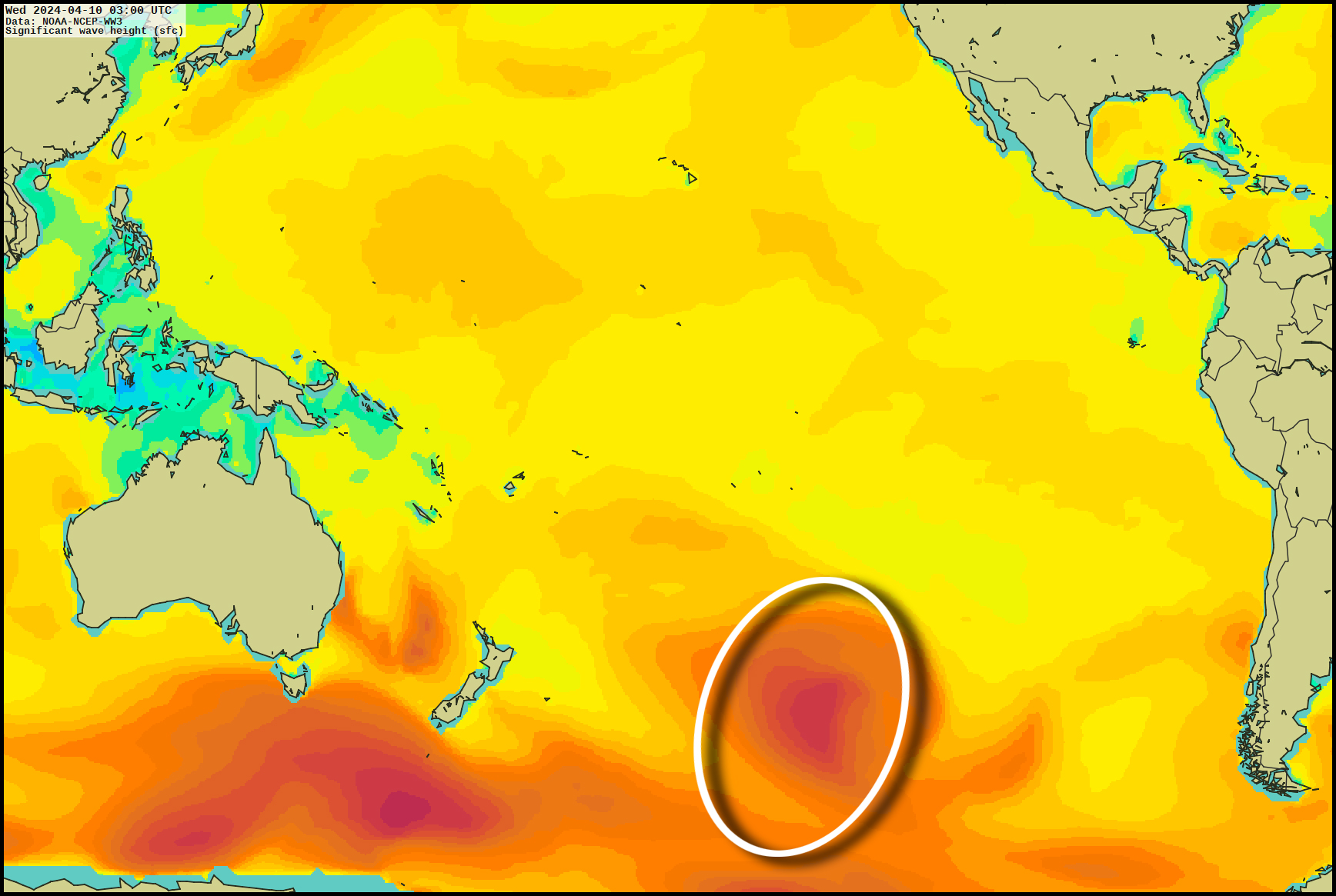
That almost direct northward course from only 4600 nautical miles from SoCal should result in chest to head high sets at south facing breaks by Wednesday the 17th, with swell angled from 195° and periods 16 seconds. This swell should continue Thursday the 18th, and then drop to chest max Friday the 19th, and waist high Saturday the 20th.
Sunday the 21st and Monday the 22nd should see waist high-ish waves at south facing breaks as continued activity in the lower latitudes will keep a steady stream of small-scaled southern hemi swell coming into SoCal, angled mostly from 185° and periods 15 seconds. We should also see minor NW wind swell Sunday the 21st through Tuesday the 23rd, providing waist high waves for west facing breaks, angled from the wind-swell-usual ≥300° with periods 8-10 seconds.
Tuesday the 23rd (building day) into Wednesday the 24th (peak) should see slightly better sized SW ground swell at south facing spots from another system in the deep low latitudes near Antarctica. Waist to chest is the call for Wednesday the 24th at south facing breaks, with swell angled from 190° and periods 15 seconds. This swell should fade to waist max Thursday the 25th, smaller Friday the 26th.
Saturday the 27th into Sunday the 28th could see a potent round of NW wind swell; if, that is, one can trust the 10-day+ models that a rogue, cut-off low would swing toward SoCal from the south, shown here on this morning's GFS model (model by NOAA MAG):
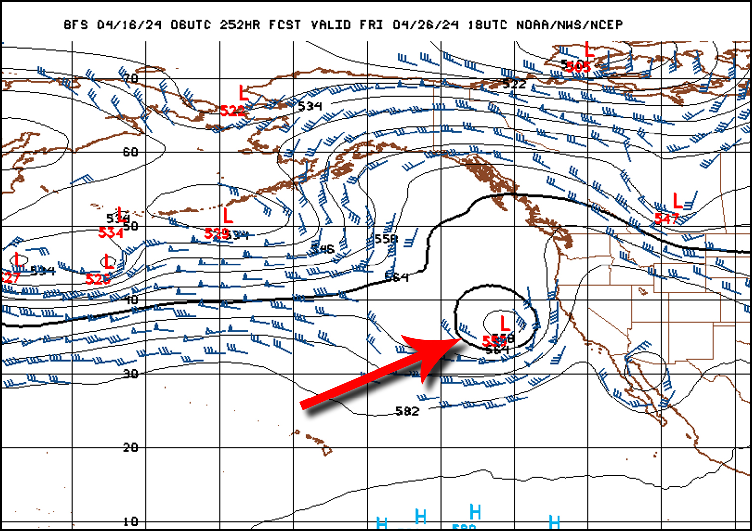
Some models show this being a more traditional trough of low pressure diving south from the Gulf of Alaska. But all models agree it'd be rain-free, bringing enough wind to kick up wind swell that could potentially run head high at west facing breaks. I'll need to see how models deal with that over the coming days.
Looking out further on the long range surf horizon, there's deadening quiet across both hemispheres for the next week to ten days. But the extended long range ensembles show storm potential near New Zealand that, being in a 9-day swell window for SoCal, gives us some rays of surfable hope around May 3rd, or the weekend of the 4th-5th. I wouldn't count my chickens just yet as these storms are far from hatching out of the South Pacific's nursery in the Southern Ocean (south of Australia where they eventually grow and turn surf-worthy for SoCal once passing New Zealand). But I'll continue to keep an eye on the SoCal surf horizon and as long as I have your support then I'll be able to keep this report going to keep you posted (more on that here).
|
|
|
Here's how the day-to-day is breaking down so far:
Wednesday the 17th should run chest to head high at south facing breaks and waist to chest at west facing spots.
Thursday the 18th looks similar.
Friday the 19th looks about chest max at south facing breaks and waist max at west facing spots.
Saturday the 20th looks about waist to chest at south facing breaks and waist max at west facing spots.
Sunday the 21st looks about waist high everywhere.
Monday the 22nd looks about waist high everywhere with occasional pluses at standout south facing breaks.
Tuesday the 23rd looks about waist high everywhere.
Wednesday the 24th, so far, looks about waist to chest at south facing breaks and waist high at west facing spots.
Thursday the 25th, so far, looks about waist high at most breaks.
Friday the 26th...no change.
Saturday the 27th may see NW wind swell fill in that would peak Sunday the 28th. This holds head high potential for west facing breaks, but it's too early to call right now.
Weather Outlook:
Today (Tuesday the 16th) should be a clear day across SoCal under moderate high pressure with beach max temps in the mid to upper 60s.
Wednesday the 17th will likely see high clouds pass overhead from a system passing far to the north. Some marine layer is possible, but not likely in many spots. Beach max temps should run in the mid to upper 60s.
Thursday the 18th sees high pressure break down as an onshore flow gets underway. The peak of the onshoreness is Friday the 19th with cloudy skies Thursday and then robust morning marine layer Friday that should clear in the afternoon. Max beach temps should run in the low to mid 60s Thursday and Friday.
Saturday the 20th into Sunday the 21st sees high pressure build into the American West. Marine layer should be minimal with early burn-offs both days, and max beach temps in the mid to upper 60s.
A robust onshore flow may get underway Monday the 22nd through Wednesday the 24th, and then we may see a cloudy day Thursday the 25th when a cut-off low could pass through SoCal. Some models show light precip sometime around Wednesday the 24th or Thursday the 25th, but we're talking about hundredths of an inch at most, so more than likely drizzle.
Wind Outlook:
Winds
at 6:00 AM (Tuesday the 16th) were light and variable most everywhere. Afternoon onshores are expected to run 15 mph at most spots, but stronger in the 20 mph range north of LA.
Wednesday the 17th should see AM light and variables with afternoon onshores 8-12 mph.
Thursday the 18th should see AM light and variables with afternoon onshores 8-12 mph.
Friday the 19th should see AM light and variables with afternoon onshores 10-15 mph.
Saturday the 20th should see AM light and variables with afternoon onshores 8-12 mph.
Sunday the 21st should see AM light and variables with afternoon onshores 8-12 mph.
Until my next report (Thursday), take care, be safe, and smile in the lineup!